There’s a version of the Tilicho Lake trek that most articles describe — moderate to challenging, high altitude, need good fitness. Then there’s the version trekkers actually experience: a narrow, landslide-prone trail cut into the wall of the Khangsar Valley, winds that arrive from nowhere at 4,900 meters, a lake so large and so improbably blue at that altitude that your brain takes a few seconds to process what you’re seeing.
Both versions are true. The difficulty classification is accurate but incomplete. What it misses is the texture of the challenge — which sections are genuinely hard and which just feel hard because you’re tired, where the real risks sit, and what kind of trekker should attempt this versus who should look at something lower first.
This guide gives you that complete picture. Altitude profiles, daily distance, terrain by section, how the Shree Kharka landslide zone actually feels on the ground, what altitude does to your body specifically at this elevation, how the difficulty compares to other Nepal treks you might have done, and what preparation actually makes a difference. By the end, you’ll know whether this trek is within your reach, what it will demand from you, and how to give yourself the best possible chance of standing at that lake.
What Kind of Trek Is Tilicho Lake Trek Difficulty?
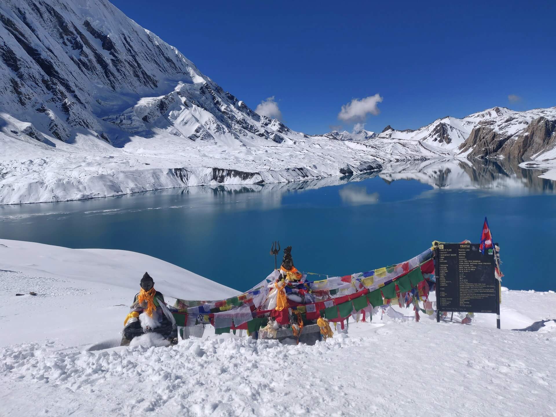
Tilicho Lake sits at 4,919 meters above sea level in the Manang district, within the Annapurna Conservation Area. It is one of the highest large glacial lakes in the world — a fact that sounds like marketing until you’re standing at the shoreline and realize the scale of what you’ve walked into.
The trek to reach it typically takes 9-12 days from Chame, or 12-16 days if starting from Besisahar at the very beginning of the Annapurna Circuit approach. Most trekkers do Tilicho as a side trip off the Annapurna Circuit, branching left at the village of Khangsar before turning back and rejoining the main circuit toward Thorong La. Some do Tilicho as the sole objective, returning the same way they came.
The official difficulty rating is moderate to challenging. A more useful framing: it’s a trek that comfortably fit, healthy adults with some prior hiking experience can complete, provided they follow proper acclimatization schedules and don’t try to push through warning signs from their bodies.
It does not require technical mountaineering skill, ropes, crampons, or prior high-altitude experience as a strict prerequisite. What it does require, without negotiation, is patience — the kind that lets you go slowly, take rest days, and stop if something feels wrong.
The Altitude Profile: What You’re Actually Climbing
Understanding the altitude profile in stages makes the difficulty tangible in a way that a single summit number doesn’t.
- The journey typically starts at Besisahar, which sits at approximately 760 meters, though most trekkers now drive by jeep from Pokhara or Kathmandu up to Chame (2,670m) or even Manang (3,500m), cutting road-walking days from the itinerary. The elevation gain on the approach varies significantly based on where you start.
- From Chame, the trail climbs gradually through Pisang (3,300m), Ngawal (3,657m), and Ghyaru (3,670m) before reaching Manang at 3,500 meters — a key acclimatization stop where every responsible itinerary builds in at least one full rest day. From Manang, the route to Tilicho branches toward Khangsar (3,734m), then Shree Kharka (4,050m), then Tilicho Base Camp (4,200-4,250m), and finally the lake itself at 4,919 meters.
- The final push from Tilicho Base Camp to the lake is roughly 700 meters of vertical gain over approximately 4-5 kilometers of trail. That number reads modestly on paper. At 4,200 meters already, with thinner air than your body is accustomed to, 700 meters of altitude gain on rocky, uneven ground takes longer than you expect. Most trekkers allow 3-4 hours for this ascent, not because the distance demands it but because the altitude does.
The total elevation gain from Manang to the lake is roughly 1,400 meters, completed over 2 days with an intermediate night at base camp. This two-stage approach is not just convenience — it’s how your body gets the time it needs to adjust.
Tilicho Lake Trek Difficulty Section by Section
Not every kilometer of this trek is equally demanding. Understanding the difficulty by section helps you plan energy and anticipate what’s coming.
Besisahar or Chame to Manang — Moderate
This is the Annapurna Circuit approach. The trail is well-trodden, well-marked, and serviced by teahouses in every village. The terrain varies from paved stone sections through villages to forest paths and river-valley trail, with gradual elevation gain of roughly 300-400 meters per day when following a sensible itinerary. The views of Annapurna II (7,937m), Pisang Peak (6,091m), and Gangapurna begin appearing as you climb. This section is busy enough during peak seasons that you’re rarely truly alone on the trail, which is reassuring for less experienced trekkers.
The landscape shifts dramatically as you approach Manang and enter the rain shadow of the Himalayas. Below Manang, you’re in lush green forest and terraced farmland. Above it, the vegetation thins, the palette desaturates to brown and grey, and the air feels noticeably different — cleaner, colder, and with less oxygen per breath than you’ve been used to.
Manang Rest Day
Manang at 3,500 meters is where every serious trekking guide insists on at least one full rest day, and they’re right to insist. This isn’t a rest day in the sense of doing nothing — it’s an acclimatization day, and the standard activity is to climb higher during the day (to the ridge above Gangapurna Lake or the ice lake above Manang at 4,600m) and return to sleep at Manang’s lower altitude.
The walk-high, sleep-low principle works because your body produces more red blood cells in response to low oxygen, and it does this more effectively when you’re spending active time at altitude during the day. Skipping this day to save time is one of the most common mistakes trekkers make on this route, and it reliably results in AMS symptoms appearing higher up where they’re harder to manage.
Manang to Shree Kharka — Moderate to Challenging
From Khangsar, the trail climbs toward Shree Kharka at 4,050 meters. The path here becomes more exposed, the vegetation drops away almost entirely, and the landscape takes on the barren, lunar quality that defines the upper Manang Valley. The views across to the Great Barrier — the massive wall of peaks separating the Manang Valley from the Tilicho area — become increasingly dramatic.
This section is moderately demanding in terms of terrain: uphill, with some rocky sections, but nothing technically complex. The challenge is predominantly altitude-related — breathing harder than you’d expect for the pace you’re walking at, stopping more frequently, feeling the weight of your pack more acutely. First-time high-altitude trekkers often experience their first genuine fatigue here, even if they’ve been feeling fine up to this point.
The Landslide Zone
Between Shree Kharka and Tilicho Base Camp lies what most experienced trekkers of this route remember as its most psychologically and physically demanding section: the traverse across the landslide zone.
This section of trail is cut into the side of a steep, unstable slope. The path is narrow — in places a meter or less in width — with a significant drop below and loose rock and scree above. There are sections where the mountain wall above the trail shows clear evidence of recent rockfall. In some stretches, you are exposed for several hundred meters at a time with minimal shelter if weather changes.
It’s worth being clear about what “landslide-prone” means in practice. The slope above the trail is geologically unstable and does shed rock and debris, particularly during and after heavy rain or in spring when snowmelt destabilizes loose material. This is not a trail you want to be on in wet weather if you can avoid it. Most experienced guides recommend crossing this section in the morning when conditions are typically calmer and any overnight moisture has had less time to loosen material.
The traverse itself takes roughly 45-90 minutes depending on pace. Most trekkers report that the anticipation is worse than the reality — the path is manageable, footing is achievable with care, and the exposure, while real, doesn’t require acrobatics.
What it requires is steady attention to where you place your feet, a willingness to move slowly, and a guide who knows the terrain well enough to time the crossing correctly.
Tilicho Base Camp to Tilicho Lake — The Hardest Day
This final ascent is where the full weight of altitude makes itself known. The trail from base camp at 4,200 meters to the lake at 4,919 meters is steep in places, rocky throughout, and exposed to wind that increases significantly as you approach the lake. The path crosses a high ridge above base camp before descending slightly and then climbing again to the lake shore.
At nearly 5,000 meters, the oxygen concentration in each breath is roughly half what you were breathing at sea level. Your body is working significantly harder than at rest even when walking slowly. Headaches, breathlessness, and fatigue are common even in well-acclimatized trekkers. The key distinction is between symptoms that are manageable and expected versus signs of acute mountain sickness that require descent — and this is where having an experienced guide who can make that judgment is genuinely valuable, not just convenient.
Most trekkers reach the lake in 3-5 hours from base camp. The turnaround is usually the same day, descending back to base camp or all the way to Shree Kharka depending on conditions and energy. Some operators run camping at the lake, though this extends the high-altitude exposure and isn’t recommended for trekkers who’ve struggled with any AMS symptoms during the approach.
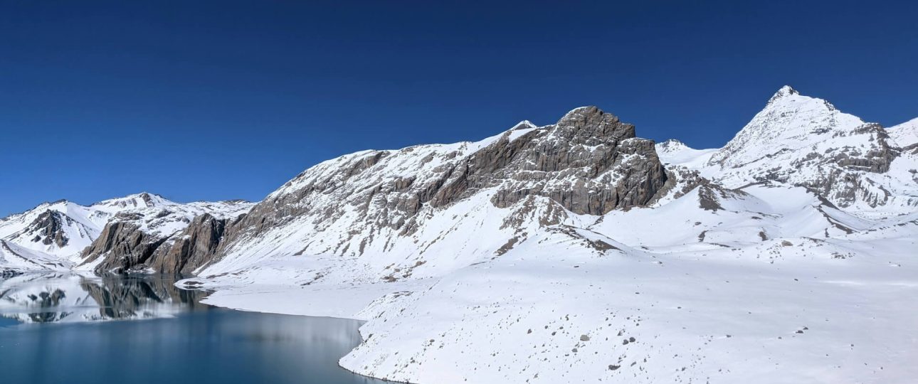
When you do arrive at the lake, the experience is difficult to describe usefully. The water shifts between deep indigo and turquoise depending on the light, framed by the massive wall of the Great Barrier and Tilicho Peak (7,134m). The scale of the surroundings relative to the lake, and the stillness at that altitude, create the kind of moment that makes the difficulty of the preceding days feel like exactly the correct amount of effort.
Altitude Sickness on Tilicho Lake Trek
Altitude sickness is the single biggest risk factor on the Tilicho Lake trek, and it deserves more than a generic warning. Understanding how it actually works — and what it actually feels like — is more useful than telling you to “listen to your body,” which is advice so general as to be nearly meaningless.
- Above 2,500 meters, the air contains measurably less oxygen per breath. Your body compensates by breathing faster, increasing heart rate, and over days producing more red blood cells. This adaptation takes time.
- The fundamental rule of high-altitude trekking is that you can outpace your body’s adaptation by ascending too quickly — and when you do, acute mountain sickness (AMS) develops.
- Mild AMS symptoms include headache, fatigue, dizziness, loss of appetite, and disturbed sleep. These are normal responses to altitude and not automatic reasons to descend — but they are signals that your body needs more time to adjust.
- The correct response to mild AMS is to stay at your current elevation (don’t ascend), rest, stay hydrated, and monitor whether symptoms are improving or worsening.
- The symptoms that require immediate descent are different: a headache that worsens despite rest and ibuprofen, loss of coordination (ataxia), confusion or difficulty thinking clearly, and any evidence of fluid in the lungs (High Altitude Pulmonary Edema, or HAPE — characterized by a wet cough, breathlessness at rest, or crackling sounds in the chest). These are medical emergencies. Descent is the cure, and it must happen immediately regardless of time of day or weather conditions.
- On the Tilicho route specifically, the two highest-risk points are the night at Tilicho Base Camp (4,200-4,250m) and the day at the lake (4,919m). Most trekkers who experience AMS beyond mild symptoms do so on the lake day, often because they’ve ignored warning signs at base camp the previous evening.
- A reasonable personal rule: if you wake at base camp with a headache that isn’t gone within 30-60 minutes of getting up and moving, the correct decision is probably to rest for another day before pushing to the lake rather than pushing on hoping the symptoms will clear with movement.
- A note on Diamox (acetazolamide): it’s widely used as a prophylactic on this trek and generally considered helpful for acclimatization. It’s not a magic solution, and it carries side effects including increased urination, tingling in the extremities, and altered taste of carbonated drinks. If you plan to use it, consult a doctor before departure, take a test dose before arriving in Nepal to check for reactions, and understand that it helps your body acclimatize but doesn’t replace proper acclimatization strategy.
Daily Distances and Walking Hours
For trekkers trying to assess the physical demand against their current fitness, the daily walking data is more useful than broad classifications like “moderate” or “strenuous.”
On the approach from Chame, daily distances range from 8-15 kilometers with 3-6 hours of walking. These are comfortable days by any standard, provided your pace matches the altitude gain rather than your fitness level on flat ground. Above Manang, daily distances drop but walking time increases because altitude slows everything down. The section from Manang to Shree Kharka covers roughly 8-9 kilometers over 4-6 hours. Shree Kharka to Tilicho Base Camp adds 6-8 kilometers and another 4-5 hours including the landslide traverse. The lake push from base camp is 4-5 kilometers each way, taking 3-5 hours up and 2-3 hours back.
Total trekking distance for the Tilicho-focused portion from Manang to the lake and back to Manang is roughly 40-50 kilometers over 4-5 days. The cumulative elevation gain on the approach to the lake from Manang is approximately 1,400 meters vertical. These are not extraordinary numbers at lower altitude. At high altitude, they’re genuinely demanding.
How Tilicho Trek Compares to Other Nepal Treks
If you’re trying to calibrate the Tilicho difficulty against treks you’ve already done or are considering, these comparisons are useful.
- Compared to the Annapurna Base Camp trek (which tops out at 4,130m), Tilicho is meaningfully harder. ABC has no significant technical terrain and a well-graduated altitude gain. Tilicho goes nearly 800 meters higher, involves the landslide traverse, and demands more from your acclimatization compliance. If you’ve done ABC comfortably and felt strong at base camp, Tilicho is a reasonable next step.
- Compared to Everest Base Camp (5,364m), Tilicho reaches a lower maximum altitude but has fewer acclimatization stages built into the standard itinerary. EBC’s classic 12-14 day itinerary is arguably more forgiving in its altitude schedule than a rushed Tilicho approach. That said, Tilicho’s off-circuit location means less infrastructure and fewer trekkers, which changes the nature of the challenge without necessarily making the altitude more dangerous.
- Compared to Thorong La Pass (5,416m) on the Annapurna Circuit, which many trekkers complete as part of the same broader journey, Tilicho Lake sits lower by about 500 meters at the maximum point. However, Thorong La is a single day’s crossing with a clear descent to Muktinath on the other side, while Tilicho involves a high-altitude night at base camp and an ascent-descent-ascent sequence that puts more cumulative stress on your system.
For first-time high-altitude trekkers, Tilicho trek is achievable but demands proper preparation, adequate time, and honest self-assessment at each stage. For trekkers with prior high-altitude experience, it’s a challenging but very manageable objective.
Tilicho Lake Trek Difficulty – Weather
The difficulty of the Tilicho Lake trek is not fixed — it moves significantly based on weather, and weather at 4,900 meters can change faster than most trekkers anticipate.
- The best seasons are October-November and March-May. October and November offer the clearest skies and most stable conditions of the year, with cold nights and crisp daytime visibility. The landscape is post-monsoon brown and grey, but the mountain views are at their best. March and April bring warmer temperatures and the possibility of snow above 4,000 meters earlier than expected, but also longer daylight hours and the beginning of spring flowering in the lower valley sections.
- Winter (December-February) is possible but significantly harder. Temperatures at Tilicho Base Camp can drop to -20°C or below at night. Some teahouses reduce operations or close entirely. Snow on the trail above Shree Kharka can make the landslide traverse dangerous. Experienced, cold-weather trekkers do complete this route in winter, but it requires specialized gear, genuine cold-weather experience, and a willingness to turn back if conditions deteriorate.
- Monsoon season (June to September) is the period most operators and guides actively discourage. The landslide zone becomes genuinely dangerous in heavy rain — not theoretically, but documented. Trails become slippery throughout, visibility is frequently poor, and the sense of exposure on the traverse is compounded by the uncertainty of what’s falling from above. Some trekkers complete the trek in the early monsoon window (late June) before peak rainfall, but this requires local weather knowledge and a guide who knows the route’s conditions intimately.
On any day above Manang, even in peak season, weather can shift within hours. A clear morning can produce afternoon cloud, and afternoon cloud at 4,800 meters can bring wind that makes forward progress genuinely difficult.
The standard practice of starting the lake push early — leaving base camp by 5:00-6:00 AM — is partly to beat altitude wind that intensifies through the afternoon.
Tilicho Lake Trek Difficulty – Physical Preparation
Most preparation advice for this trek is generic in the least useful direction — “get fit, do cardio.” Here’s what actually corresponds to the demands of the trail.
- The most important physical attribute for this trek isn’t raw fitness. It’s cardiovascular efficiency — how well your heart and lungs move oxygen under load. Running, cycling, and swimming for 30-45 minutes consistently three to four times a week for 8-12 weeks before your departure builds this effectively. You don’t need to be an athlete, but you need your cardiovascular system to be regularly challenged before you ask it to work at altitude.
- Leg strength and endurance matter because the descents are where most trekking injuries happen. Downhill puts eccentric load on your quadriceps — the muscles work in their lengthened position, which they’re typically weaker in unless you’ve trained specifically for it. Hill walks with a loaded pack, stair climbing, and lunges build this capacity more specifically than flat running.
- Carrying your own pack matters. Hiring a porter means someone else carries your main bag, but you’ll still carry a daypack for water, snacks, extra layers, camera, and rain gear. Training with a 5-8 kg pack on any of your regular exercise sessions conditions your back, hips, and shoulders for the cumulative load.
If you have access to altitude, use it. Even day trips to elevations above 3,000 meters in the 6-8 weeks before your trek help condition your body’s altitude response. If you’re trekking from a low-altitude home country without access to elevation, the next best preparation is maintaining aerobic fitness and giving yourself time — don’t rush the acclimatization stages when you’re on the trail.
Is Tilicho Lake Trek Right for You?
Rather than a blanket statement about who can or can’t do this trek, consider these honest questions.
- Have you done multi-day trekking before? Not necessarily at altitude, but overnight backcountry trips where you’ve carried a pack for 5-8 hours over consecutive days. If the answer is no, a shorter, lower-elevation Nepal trek first — Ghandruk, Poon Hill, or a lower-level Annapurna approach — gives you a much better read on how your body responds to sustained walking and what equipment you actually need.
- Are you comfortable making decisions based on physical signals? The hardest thing about high-altitude trekking isn’t the physical difficulty. It’s turning back when you’ve already invested 10 days and considerable money into reaching a specific destination. People who override clear AMS warning signs because of sunk cost or ego make up a disproportionate share of helicopter rescue statistics. Tilicho Lake will still exist next season. If your judgment in difficult situations trends toward pushing through rather than stepping back, this is worth reflecting on before you commit.
- Do you have the time for proper acclimatization? A 9-10 day minimum itinerary from Chame to the lake and back is the fastest responsible version of this trek, and it assumes no delays, no AMS complications, and good weather for the lake day.
- Most experienced operators recommend 12-14 days for trekkers without prior high-altitude experience, or those combining Tilicho with the full Annapurna Circuit and Thorong La Pass. If you’re squeezing this trek into a tight schedule and the option of adding days if needed doesn’t exist, that’s a genuine risk factor.
Frequently Asked Questions About Tilicho Lake Trek Difficulty
- How difficult is the Tilicho Lake trek?
It’s classified as moderate to challenging. The difficulty comes primarily from altitude — the lake sits at 4,919 meters — combined with the technical nature of the landslide traverse between Shree Kharka and Tilicho Base Camp. The trail requires no mountaineering skill, but demands good cardiovascular fitness, compliance with acclimatization schedules, and honest self-assessment of symptoms above 4,000 meters. - Is the Tilicho Lake trek suitable for beginners?
It’s possible for well-prepared beginners, but not recommended as a first trekking experience. Prior multi-day trekking, a good fitness foundation, and a longer-than-minimum itinerary with proper acclimatization days significantly increase the chances of a successful and safe experience. First-time trekkers who rush the approach or skip rest days in Manang are the most common candidates for helicopter evacuation on this route. - How long does the Tilicho Lake trek take?
A standalone Tilicho trek typically takes 9-12 days. Combined with the full Annapurna Circuit and Thorong La Pass crossing, the total journey runs 14-18 days. Most reputable operators recommend adding one extra buffer day to any itinerary to accommodate weather delays or acclimatization needs. - What is the most dangerous section of the Tilicho Lake trek?
The traverse across the landslide zone between Shree Kharka and Tilicho Base Camp is the most technically demanding and objectively hazardous section, particularly in wet conditions. The second major risk is altitude sickness on the lake day ascent from base camp. Crossing the landslide zone in the morning when conditions are drier and calmer significantly reduces the first risk. Following proper acclimatization and not ascending with AMS symptoms manages the second. - Can you do the Tilicho Lake trek without a guide?
Nepal’s guide regulations for the Annapurna Conservation Area in 2026 are inconsistently enforced, but above Manang on the Tilicho side branch specifically, a guide is strongly recommended on practical safety grounds regardless of regulatory requirements. The landslide traverse requires local knowledge about timing and conditions. AMS recognition and the decision to descend or continue requires someone experienced in making that judgment. The trail above base camp is less marked than lower sections. A guide here is genuinely functional, not ceremonial. - How much altitude gain is there on the Tilicho Lake trek?
From Chame (2,670m) to the lake (4,919m), the total altitude gain is approximately 2,250 meters, spread across 9-10 days with rest days built in. The steepest single-day gain is on the lake day itself, where trekkers climb roughly 700 meters vertical from Tilicho Base Camp to the lake in 4-5 kilometers of trail at maximum altitude. - What are the early symptoms of altitude sickness on this trek?
The most common early warning signs are a persistent headache, loss of appetite, fatigue that seems disproportionate to the day’s effort, and disturbed sleep. These are normal at altitude and not automatic reasons to descend — but they indicate your body needs more time. Symptoms requiring immediate descent are a headache that worsens despite rest, loss of coordination, confusion, and any wet cough or breathlessness at rest. - What is the best time of year to do the Tilicho Lake trek?
October and November offer the most reliable weather, clearest skies, and most stable trail conditions. March to May is the second-best window, with the added visual of rhododendron bloom in the lower valley sections and warmer daytime temperatures. Both peak windows see the most trekking traffic on the Annapurna Circuit approach, though the Tilicho side branch remains quieter than the main circuit in all seasons. - How does the Tilicho Lake trek compare to Everest Base Camp in difficulty?
They’re comparable in the altitude-related demands. EBC reaches slightly higher (5,364m) but has a more graduated altitude profile and arguably better infrastructure. Tilicho’s landslide traverse has no equivalent on the EBC route. Trekkers who’ve completed EBC comfortably will find Tilicho’s altitude familiar; the terrain challenge on the Khangsar approach is the new variable. - Do you need to camp on the Tilicho Lake trek, or can you stay in teahouses?
For most of the route, teahouses are available through Tilicho Base Camp. A basic lodge operates at base camp, making tent camping unnecessary for the standard itinerary. The lake itself has no permanent accommodation. Some operators run camping trips at the lake, but this involves a night at 4,919 meters — a high-altitude exposure that’s not recommended for trekkers who’ve experienced any AMS symptoms during the approach.
Final Word about Tilicho Lake Trek Difficulty
There’s a tendency to approach a trek like Tilicho by focusing on whether you can do it. The more interesting question — once you’ve assessed your fitness and preparation honestly — is whether you’re willing to do it correctly.
Correctly means slowly. It means taking the rest day in Manang even when you feel fine and are eager to push on. It means crossing the landslide zone with attention rather than speed. It means deciding, the morning you leave for the lake, whether your body’s signals from the night at base camp are telling you something that deserves to be listened to. It means hiring a guide who has made this journey enough times to know the difference between normal altitude fatigue and something that needs action.
Tilicho Lake at 4,919 meters is one of the more extraordinary places you can reach on foot in the world — a glacial lake of extraordinary size and color, surrounded by peaks that dwarf anything most trekkers have stood near before, accessible without technical climbing to anyone who’s willing to take the altitude seriously and go slowly enough to let their body keep up.