Introduction to Annapurna Base Camp Trek Map
The Annapurna Base Camp trek map shows a single main trail that leads into the Annapurna Sanctuary, with flexible entry and exit options in the lower section. The core route runs from Pokhara through villages like Ghandruk and Chhomrong, then follows the Modi Khola valley through Bamboo, Dovan, and Deurali to Machhapuchhre Base Camp and finally Annapurna Base Camp at 4,130 meters .
Most trekkers look for an Annapurna Base Camp trek map to understand one simple thing: how the route actually flows. With multiple starting points, village names, and route variations, the trail can feel confusing without a clear visual reference.
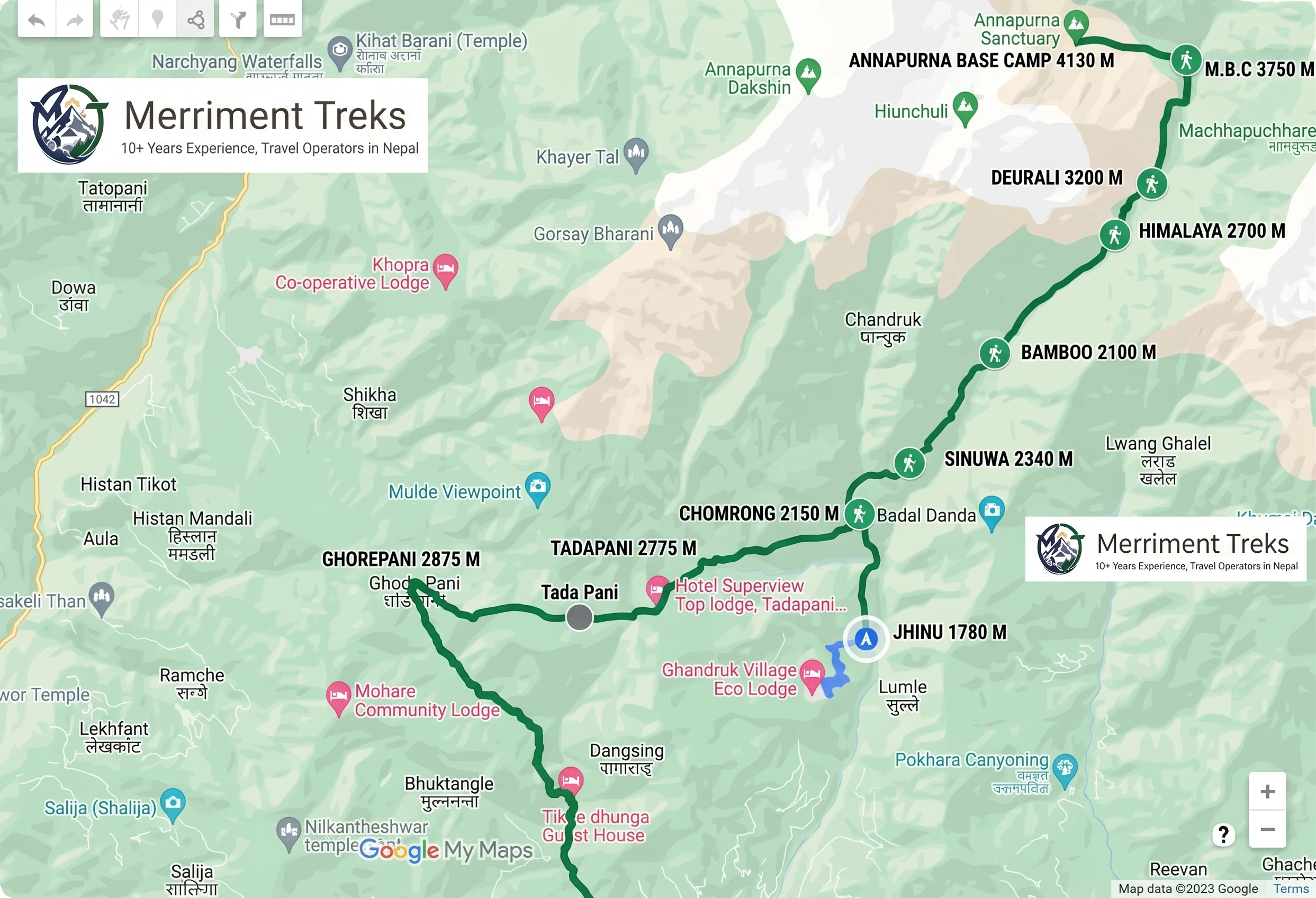
Annapurna Base Camp Trek Map: Key Route Overview
| Information | Details |
|---|---|
| Trek region | Annapurna Conservation Area, Nepal |
| Trail type | Out-and-back with route variations |
| Highest point | Annapurna Base Camp (4,130 m / 13,550 ft) |
| Main access hub | Pokhara (820 m) |
| Key junction | Chhomrong (2,170 m) |
| Core trail | Shared sanctuary route after Chhomrong |
| Major alternative | Poon Hill detour (adds 2-3 days) |
| Total distance | 110–115 km round-trip (standard route) |
| Permit checkpoint | Birethanti (ACAP and TIMS first stamp) |
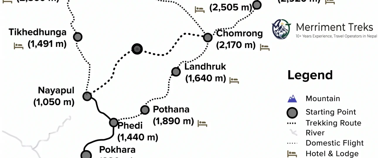
The map shows one main trail into the Annapurna Sanctuary, with flexible entry and exit points in the lower section . All routes merge near Chhomrong and follow the same trail to Annapurna Base Camp .
How to Read the Annapurna Base Camp Trek Map
The solid trekking line on the map shows the walking trail, while road sections indicate driving routes such as Kathmandu to Pokhara and Pokhara to Nayapul .
Village names are marked with altitudes, which are more important than distance. These altitude points show how the trek gains height gradually rather than through sudden climbs . Once the route reaches Chhomrong, the trail becomes a single, well-defined path toward Machapuchare Base Camp and Annapurna Base Camp .
What to Look For on the Map
-
Village names and elevations — Updated with latest information from the Annapurna region
-
Teahouse availability — Locations of accommodation in each village
-
Suspension bridges — All hanging bridges encountered during the trek
-
Viewpoints — Panoramic viewpoints along the hiking trails
-
Main trekking route — Clearly marked with altitude points, distance markers, and time estimates between villages
-
Permit checkpoints — ACAP verification points at Birethanti and Chhomrong
Interactive vs Physical Maps
Digital/interactive maps provide real-time guidance on paths, nearby landmarks, and your location, including live weather forecasts and altitude tracking. An interactive topographic map of the Annapurna Base Camp Trek is available in full resolution (8,322 x 7,100), precisely geolocated to showcase even the most minor details . When you navigate to the map page, you can zoom in and out. In the top left corner, you will find icons for zooming in and out. Clicking the zoom-in icon allows you to view the map in its original quality .
Physical/paper maps are essential because they don’t need batteries, signals, or networks. They provide a reliable backup whenever digital devices don’t work properly. The Annapurna Base Camp trekking map at 1:50,000 from Nepa Maps covers the route from Pokhara to Annapurna’s South Base Camp and the Machhapuchhre Base Camp, including climbing routes to Tharpu Chuli and Singu Chuli . Contours are at 40m intervals, and a route profile with stages in metres and feet plus trekking times is included .
Legend and Symbols
The map’s legend includes :
-
Blue lines — Rivers and streams
-
Dotted tracks — Driveways and road sections
-
Small mountain icons — Locations of peaks in the Annapurna region
-
Numbering — Helps determine the order of villages for overnight stays
-
Contour lines — Shows terrain elevation changes
-
Boundaries — National Park and conservation area boundaries
Annapurna Base Camp Route Explained (By Trekking Phase)
Phase 1: Starting Point and Entry into the Trail
The journey begins with a drive from Kathmandu to Pokhara, followed by another drive to Nayapul. Trekking starts from Nayapul at a low altitude, allowing an easy transition into daily walking .
From here, the trail climbs toward villages such as Ghandruk. This section introduces trekkers to village paths and stone steps, with steady elevation gain rather than steep ascents .
An alternative starting point is Kimche village, reachable by jeep from Pokhara. This option bypasses the lower valley stages and deposits trekkers directly at the Ghandruk elevation level, shortening the overall route by 1 walking day .
Permit checkpoint: The permit checkpoint at Birethanti marks the formal entry into the trekking route. Both ACAP and TIMS permits receive their first stamp at this checkpoint — trekkers without valid permits are turned back here .
Phase 2: Villages to Valley Route
From Ghandruk, the trail moves toward Chhomrong, a key junction where most routes merge. After Chhomrong, the path drops to the river and climbs again through Bamboo and Dovan .
This section follows the Modi Khola valley, with denser forests, fewer villages, and a gradual increase in altitude. By the time trekkers reach Deurali, the environment feels colder and more open, signaling entry into higher terrain .
Ghandruk to Chhomrong (1,940m → 2,170m): The trail descends briefly from Ghandruk through Kimche before crossing the Chhomrong Khola and climbing to Chhomrong. This section passes through open hillside and terraced farmland with the Annapurna range increasingly dominant on the northern horizon. Chhomrong is the pivotal junction on the entire route — trails diverge here toward the Poon Hill approach from the north and the Ghandruk return from the south. Every trekker heading to the sanctuary passes through Chhomrong in both directions, and it serves as the last fully-serviced village before the gorge .
Chhomrong to Bamboo (2,170m → 2,310m): Below Chhomrong the route changes character entirely. The long stone staircase descends steeply to the Chhomrong Khola crossing, then climbs back up through Sinuwa before the forest closes in above. The bamboo and rhododendron gorge above Sinuwa is one of the most atmospherically distinctive sections of any Nepal trekking route — cathedral forest, constant river sound, waterfalls on the walls above, and the trail becoming increasingly narrow and remote. The teahouses at Bamboo sit in the deepest section of this forest at 2,310m .
Bamboo to Deurali (2,310m → 3,230m): The gorge narrows further above Bamboo as the trail passes through Dobhan and Himalaya Hotel before the forest begins to open and the first high peaks appear above the valley walls. The gradient increases steadily and by Deurali at 3,230m the trail sits at the transition between gorge and sanctuary — the dense forest behind and the open glacial terrain ahead. The Annapurna peaks are now consistently visible above the valley and the scale of the mountains becomes apparent for the first time .
Phase 3: Upper Sanctuary Route
Above Deurali, the trail enters the Annapurna Sanctuary. The landscape opens into a wide alpine valley, and walking becomes slower due to altitude rather than steep terrain .
Machapuchare Base Camp sits just below Annapurna Base Camp and is a common stopping point. From here, the final walk to Annapurna Base Camp is short and gradual, leading to the highest point of the trek at 4,130 meters .
Deurali to Annapurna Base Camp (3,230m → 4,130m): Above Deurali the trail enters the open glacial moraine of the Annapurna Sanctuary approach. Machapuchare Base Camp at 3,700m provides the first close-range view of the fish-tail summit directly overhead. The trail continues up the moraine through increasingly open terrain to base camp at 4,130m — where the sanctuary enclosure reveals itself fully. Annapurna I, Gangapurna, Hiunchuli, Annapurna South, and Machapuchare surround the basin on all sides. Unlike EBC where Everest is hidden from base camp by Nuptse, every major peak is fully visible from the Annapurna Sanctuary .
Phase 4: Return Route and Exit
The return follows the same valley back down, with altitude decreasing steadily. Many trekkers choose to exit via Jhinu Danda, which offers a gradual descent and access to natural hot springs before returning to Pokhara .
Phase 5: Village and Overnight Stop Guide
| Village | Altitude | Key Facilities | Notes |
|---|---|---|---|
| Ghandruk | 1,940m | Good teahouses, ATM, shops | Traditional Gurung village — best lower-trail stop |
| Chhomrong | 2,170m | ATM (last on route), shops, hot showers | Gateway to sanctuary — last reliable ATM and shower |
| Bamboo | 2,310m | Basic teahouses, river water | Deep gorge setting — atmospheric overnight |
| Deurali | 3,230m | Basic teahouses, limited facilities | First night above 3,000m — mild altitude effects possible |
| MBC | 3,700m | Small teahouses | Transit stop — Machapuchare summit directly above |
| Annapurna Base Camp | 4,130m | Basic teahouses, very limited | Highest overnight — cold, open, spectacular |
| Jhinu Danda | 1,780m | Teahouses, natural hot springs | Hot springs 10 min walk — reward stop |
Complete Village List with Elevations
The Annapurna Base Camp route passes through 13 primary stops :
| Stop | Elevation | Key Feature |
|---|---|---|
| Birethanti | 1,025 m | Trek start, permit checkpoint |
| Tikhedhunga | 1,540 m | Waterfall viewpoint, stone steps begin |
| Ulleri | 1,960 m | 3,444-step Gurung village ascent |
| Ghorepani | 2,874 m | Gateway to Poon Hill sunrise viewpoint |
| Tadapani | 2,590 m | Rhododendron forest junction |
| Ghandruk | 1,940 m | Gurung Museum, cultural hub |
| Chhomrong | 2,170 m | Last ATM, final cellular connection |
| Sinuwa | 2,360 m | Canyon entry, teahouse cluster |
| Bamboo | 2,310 m | Bamboo forest zone |
| Doban | 2,630 m | River confluence, suspension bridges |
| Himalaya | 2,920 m | Hiunchuli south wall viewpoint |
| Deurali | 3,200 m | Sanctuary boundary, snow zone begins |
| Machhapuchhre Base Camp | 3,700 m | Fishtail Mountain close approach |
| Annapurna Base Camp | 4,130 m | 360-degree summit panorama |
Ghandruk and Chhomrong are the two largest inhabited villages on the route, serving as commercial teahouse hubs with internet access, full meal services, and medical kit availability. Ghandruk holds 1,200 permanent Gurung residents and is classified as one of Nepal’s most significant Gurung heritage settlements .
Above Bamboo, permanent settlements end. Himalaya, Deurali, MBC, and ABC operate exclusively as seasonal teahouse facilities, open from October through May. These upper stations close or significantly reduce services during June through September monsoon season .
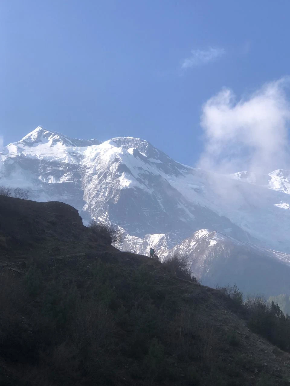
Annapurna Base Camp Trek Route: Day-by-Day Itinerary
11-Day Classic Itinerary via Poon Hill
This is the most popular and rewarding route variation, combining cultural immersion with breathtaking panoramic mountain views .
| Day | Route | Key Highlights |
|---|---|---|
| 1 | Drive Kathmandu to Pokhara | Scenic drive along Trishuli and Marsyangdi rivers |
| 2 | Drive to Tikhedhunga, trek to Ulleri | Famous stone steps begin |
| 3 | Trek to Ghorepani | Rhododendron forests, views of Annapurna and Machhapuchhre |
| 4 | Poon Hill sunrise, trek to Tadapani | Sunrise over Annapurna and Dhaulagiri ranges |
| 5 | Trek to Chhomrong | Traditional Gurung villages, views of Annapurna South |
| 6 | Trek to Bamboo | Cross Chhomrong Khola, bamboo forests |
| 7 | Trek to Deurali | Pass Hinku Cave, enter alpine zone |
| 8 | Trek to ABC via MBC | Enter Annapurna Sanctuary, 360-degree views |
| 9 | Descend to Bamboo | Retrace trail through Modi River Valley |
| 10 | Trek to Jhinu Danda | Natural hot springs |
| 11 | Drive to Pokhara | Final short trek, scenic return |
Direct Route (Without Poon Hill)
The direct route to Annapurna Base Camp bypasses Poon Hill and Ghorepani, offering a faster, more focused approach to the sanctuary. This variation appeals to trekkers with limited time or those who have already experienced Poon Hill on previous treks .
| Day | Route | Distance |
|---|---|---|
| 1 | Birethanti → Jhinu Danda | 12 km |
| 2 | Jhinu Danda → Chhomrong | — |
| 3 | Chhomrong → Bamboo | 9 km |
| 4 | Bamboo → Deurali | 7.3 km |
| 5 | Deurali → ABC (via MBC) | — |
Short Route (Starting from Siwai or Jhinu Danda)
The short ABC trek is designed for time-constrained trekkers who want to experience the Annapurna Sanctuary without spending two weeks on the trail. This condensed itinerary requires good fitness levels and rapid acclimatization .
| Day | Route | Distance |
|---|---|---|
| 1 | Pokhara → Siwai → Chhomrong | 15 km trek |
| 2 | Chhomrong → Bamboo → Deurali | — |
| 3 | Deurali → ABC → MBC | — |
| 4 | MBC → Bamboo | 16.5 km |
| 5 | Bamboo → Jhinu Danda → Pokhara | 13 km trek |
Understanding the Altitude Profile
The altitude chart shows a steady ascent from the lower villages to Annapurna Base Camp, followed by a gradual descent. There are no sudden altitude jumps on the route, which explains why acclimatization on the Annapurna Base Camp trek is generally smooth when the trail is followed at a normal pace .
Key Altitude Points
| Stop | Elevation (m) | Elevation (ft) |
|---|---|---|
| Pokhara | 820 m | 2,690 ft |
| Nayapul | 1,070 m | 3,510 ft |
| Ghandruk | 1,940 m | 6,365 ft |
| Chhomrong | 2,170 m | 7,119 ft |
| Bamboo | 2,310 m | 7,579 ft |
| Dovan | 2,630 m | 8,629 ft |
| Himalaya | 2,920 m | 9,580 ft |
| Deurali | 3,230 m | 10,597 ft |
| MBC | 3,700 m | 12,139 ft |
| ABC | 4,130 m | 13,549 ft |
Total Elevation Gain
The standard Annapurna Base Camp Trek Route covers 110 to 115 kilometers round-trip over 7 to 14 days . Total ascent from trailhead to base camp accumulates 3,060 meters of elevation gain across the route. The one-way distance from Nayapul to Annapurna Base Camp is approximately 55 kilometers .
As it demonstrates the gradual rise to Annapurna Base Camp (4,130m) and subsequent descent in detail, the altitude chart allows trekkers to expect difficult stages, adjust the speed of trekking, and reduce the probability of altitude sickness .
Duration Breakdown by Itinerary Type
-
7-day express route: For physically fit trekkers with prior high-altitude experience and minimal rest stops
-
10-day standard route: For moderately fit trekkers with average hiking experience, including 1 full rest day at Ghandruk or Chhomrong
-
12–14 day extended route: For first-time high-altitude trekkers or those exploring side routes, Poon Hill sunrise, Jhinu Danda hot springs, or the Mardi Himal viewpoint detour
The 10-day standard itinerary represents the most balanced approach. It provides sufficient time for altitude adjustment, cultural exploration at Ghandruk, and comfortable daily walking distances averaging 12–16 kilometers per day .
Main Annapurna Base Camp Route vs Route Variations
Route Comparison Table
| Feature | Classic via Ghandruk | Via Poon Hill | Direct/Short |
|---|---|---|---|
| Total distance | 110–115 km | ~125–130 km | ~70–90 km |
| Duration | 8–10 days | 10–12 days | 7–9 days |
| Highest point | ABC (4,130m) | ABC (4,130m) | ABC (4,130m) |
| Key extra | — | Poon Hill sunrise (3,210m) | Speed focus |
| Best for | Most trekkers | First-timers, photographers | Limited time, good fitness |
There is one main sanctuary route to Annapurna Base Camp. Different routes only affect how trekkers enter or exit the trail :
-
Ghandruk Route: Common entry option
-
Jhinu Danda Route: Common exit option
-
Scenic Extensions (e.g., Poon Hill): Optional add-ons outside the sanctuary
All routes merge near Chhomrong and follow the same trail to Annapurna Base Camp .
Annapurna Base Camp Trek Map vs Annapurna Circuit Map
| Feature | ABC Trek | Annapurna Circuit |
|---|---|---|
| Route type | Out-and-back with variations | Circular loop |
| Total distance | 70–115 km | 160–230 km |
| Duration | 7–12 days | 14–20 days |
| Highest point | ABC (4,130 m) | Thorong La (5,416 m) |
| Teahouse density | High throughout | High throughout |
| Road access | Multiple start/end options | Some road sections |
| Map complexity | Simple single corridor | Complex with multiple passes |
| Permit checkpoints | Birethanti, Chhomrong | Multiple across route |
Navigation Tips for the ABC Trek
Offline Maps and GPS
Having both a digital and physical map is crucial for the Annapurna Base Camp trek. For a secure journey, it is best to have both .
Digital maps combined with GPS provide real-time guidance on paths, nearby landmarks, and your location. They can also show live weather forecasts and track changes in your altitude .
Physical/paper maps are essential because they don’t need batteries, signals, or networks. They are usable for a long period and provide a reliable backup whenever digital devices don’t work properly .
Phone Battery and Power Banks
Cell service is spotty on certain parts of the trail, so offline maps are essential. Carry a portable power bank for device charging at higher elevations where electricity is limited .
Trail Signs and Local Guidance
In most villages, you will see signs that have names and directions corresponding to what is on the map. You can also ask local people or lodge owners for help — they are familiar with the route .
Weather and Navigation
Annapurna Base Camp weather can change rapidly. In fog or snow, the trail can be harder to follow. Use both map and local guidance to stay on track.
Special Navigation Considerations
-
Monsoon season: Trail conditions change; check with locals
-
Winter trekking: Snow can obscure trail markers; use GPS and guides
-
Shortcut routes: Some maps show side trails; confirm they are passable
-
Take a screenshot of your digital map in case of no signal
What the Map Does Not Tell You
The Annapurna Base Camp trek map shows the route, but it cannot show :
-
Trail conditions — Stone steps, mud, or ice can change difficulty significantly
-
Weather — Afternoon clouds, rain, or snow can affect visibility and safety
-
Physical difficulty — The map shows altitude but not how your body will respond
-
Altitude response — Acclimatization varies by person, not by what the map shows
-
Crowds — Peak season brings busy trails and full teahouses
-
Seasonal changes — The route looks different in spring vs. monsoon vs. winter
-
Actual walking pace — 3 km at 4,000 m takes much longer than 3 km at 1,000 m
Why These Gaps Matter
The map shows the starting point, villages, and altitude, but trekkers should not assume that 4,130 meters is the only challenge. The short 3–4 km section from MBC to ABC can take 2–2.5 hours due to altitude .
The longest day on the trail map (ABC to Bamboo, 12–13 km) can take 6–7 hours. The map shows distance but not the 1,780-metre descent that makes this day particularly challenging.
Best Way to Plan Your ABC Trek Using the Map
Step 1: Choose Your Route
-
Classic via Ghandruk (8–10 days) — Best for most trekkers
-
Via Poon Hill (10–12 days) — Best for sunrise views and first-timers
-
Direct/Jhinu Danda start (7–9 days) — Best for limited time
Step 2: Plan Daily Distances
The Annapurna Base Camp Trek Map shows daily walking sections, altitude gain, overnight stops, driving routes, and important highlights along the way . Use the map to check daily walking distances and altitude changes. If you are a beginner, keep daily distances under 12 km.
Step 3: Check Accommodation Locations
The map shows tea houses in each village. Plan overnight stops at villages with adequate accommodation, especially during peak season . Carry both digital and physical maps .
Step 4: Factor in Altitude
The map shows altitude progression. Slow down above 3,000 meters and consider an extra night at MBC before reaching ABC.
Step 5: Add Buffer Days
Weather, altitude, or fatigue may require an extra day. The map can help you identify flexible stopping points.
Step 6: Verify Your Capabilities
You can verify whether the online itinerary you received aligns with your capabilities. It helps you plan a day-to-day itinerary based on your fitness level and lets you decide where you would like to spend the night .
Practical Tips From a Trekking Perspective
Before You Start
-
Download offline maps before you go, as cell service is spotty on certain parts of the trail
-
Purchase a physical map — Available at Kathmandu or Pokhara bookstores
-
Check the map for teahouse locations — Know where you can stop if needed
-
Review elevation changes — Use the altitude profile to plan rest days
On the Trail
-
Carry both digital and physical maps — Technology is not always reliable
-
Take a screenshot of your digital map — In case of no signal
-
Look for trail signs — They correspond to map information
-
Ask locals — They know the trail and can confirm your location
Understanding Map Symbols
-
Numbering helps you determine the order of villages for overnight stays
-
The map is color-coded and a straightforward guide that makes the Annapurna Base Camp trek easier for first-timers or beginner trekkers
-
You can check the elevation changes without needing a guidebook or an internet search, which is unreliable most of the time
Why Choose Merriment Treks for Your ABC Trek?
If you are planning your Annapurna Base Camp trek, Merriment Treks offers itineraries designed with clear route and map planning.
What makes them different:
-
Route expertise — Deep knowledge of the Annapurna Base Camp trail and variations
-
Customised itineraries — Choose between Poon Hill, direct, or short routes
-
Licensed guides — Trained in route navigation and altitude safety
-
Map and planning support — Helping you understand the route before you arrive
-
Teahouse recommendations — Based on real local knowledge
-
Permit assistance — Including ACAP and TIMS requirements
-
Complimentary maps — Physical maps provided during trip meetings in Kathmandu
Merriment Treks can help you choose the right route based on your fitness, available time, and preferences.
Frequently Asked Questions about Annapurna Base Camp Trek Map
1. Where does the Annapurna Base Camp trek start?
Most trekkers start from Nayapul or Siwai, a 1–2 hour drive from Pokhara. Some shorter itineraries start from Jhinu Danda. An alternative starting point is Kimche village, reachable by jeep from Pokhara, which bypasses the lower valley stages .
2. Where is Annapurna Base Camp located?
Annapurna Base Camp is located at 4,130 meters in the Annapurna Sanctuary, surrounded by Annapurna I, Annapurna South, Hiunchuli, and Machhapuchhre .
3. What route does the ABC trek follow?
The route follows the Modi Khola valley through Ghandruk, Chhomrong, Bamboo, Dovan, Deurali, Machhapuchhre Base Camp, and then Annapurna Base Camp .
4. What are the major stops on the Annapurna Base Camp trek?
The route passes through 13 primary stops: Birethanti, Tikhedhunga, Ulleri, Ghorepani, Tadapani, Ghandruk, Chhomrong, Sinuwa, Bamboo, Doban, Himalaya, Deurali, Machhapuchhre Base Camp, and Annapurna Base Camp .
5. What is the highest point on the ABC trek?
The highest point is Annapurna Base Camp at 4,130 meters .
6. How far is Annapurna Base Camp from Pokhara?
The straight-line distance is approximately 40–50 km, but the trekking distance is 70–115 km depending on the route .
7. How many days does the Annapurna Base Camp trek take?
7–12 days, with 10 days being the most balanced option. A 14-day extended itinerary is available for those wanting a relaxed pace and cultural exploration .
8. Is the Annapurna Base Camp route difficult?
The route is considered moderate. It involves steep stone stairs and altitude up to 4,130 meters but requires no technical climbing .
9. Can I use Google Maps on the ABC trek?
Google Maps does not show the trail reliably. Use dedicated trekking apps like Maps.me, AllTrails, or offline trekking maps .
10. Do I need an offline map for Annapurna Base Camp?
Yes. Cell service is spotty on parts of the trail, so offline maps are essential .
11. Is GPS available on the Annapurna Base Camp trail?
GPS works along most of the trail, but battery life and weather conditions can affect accuracy. Bring backup power .
12. Does the ABC route change depending on the starting point?
The main sanctuary route is the same once you pass Chhomrong. Route variations only affect how you enter or exit the trail .
13. Is Annapurna Base Camp the same as Machhapuchhre Base Camp?
No. Machhapuchhre Base Camp is at 3,700 meters and is a stopping point en route to Annapurna Base Camp at 4,130 meters .
14. Is the Annapurna Base Camp trek safe for beginners?
Yes, with proper preparation. The route is well-marked and teahouse infrastructure is excellent. Choose a 10–12 day itinerary for safer acclimatization .
15. What should I check on the map before starting the trek?
Check the starting point, daily walking distances, altitude changes, teahouse locations, permit checkpoints, and potential side routes or alternative exits .