Where Is Mount Everest Located on a Map
Mount Everest is located on the international boundary between Nepal and the Tibet Autonomous Region of China. Its summit—at precisely 27.9881° N latitude and 86.9250° E longitude—sits directly on this border, with the southern face falling within Nepal’s Sagarmatha National Park and the northern face extending into Chinese-administered Tibet. If you search for where Mount Everest is located on a map, the answer lies not in one country but on the line that separates two.
This geographic reality creates the confusion behind so many searches. Some maps show Everest Base Camp inside Nepal. Others place it squarely in Tibet. The most accurate maps display it straddling both. At Merriment Treks, we guide travelers through the Khumbu Valley on the Nepal side, and we have learned that understanding Everest’s location requires understanding how borders, mountain ranges, and remote geography interact. This guide explains exactly where the mountain sits, how to find it on different map types, and why the answer is more nuanced than a single country name.
The Immediate Answer: Where Is Mount Everest on a World Map
To locate Mount Everest on a world map, you need to find three reference points. First, identify Asia. Second, locate the Indian subcontinent—the triangular landmass extending south into the Indian Ocean. Third, trace the northern edge of this landmass to the curved mountain belt known as the Himalayas. Mount Everest sits in the central portion of this range, approximately at 28 degrees North latitude and 87 degrees East longitude.
This position places Everest in South Asia, within the northern reaches of Nepal and the southern edge of the Tibetan Plateau. The mountain is not in the far north or extreme east of Asia. It is almost perfectly positioned at the collision zone where the Indian tectonic plate meets the Eurasian plate, creating the highest elevations on Earth.
Why the Location Confuses People: The Border Problem
The question where Mount Everest is located often masks a deeper question: which country does it belong to? The answer is both Nepal and China, but this shared arrangement is unusual in world geography. Most famous landmarks sit entirely within one nation. The Eiffel Tower is in France. The Grand Canyon is in the United States. Mount Everest is different.
The summit ridge forms a natural boundary that has become a political border. When surveyors and diplomats negotiated the Nepal-China border in the 1960s, they followed the watershed line that Everest defines. This means the highest point on Earth is also a geopolitical dividing line. A climber standing on the summit has one foot on the Nepali side and one foot on the Chinese side—geographically speaking.
For map readers, this means Everest appears differently depending on map type. Political maps emphasize country borders, often placing Everest directly on the line. Physical maps show the mountain as part of the Himalayan crest. Some simplified maps err by assigning the entire peak to one country or the other. This inconsistency fuels the search for a definitive answer.
The Geographic Hierarchy: Placing Everest in Context
Understanding Mount Everest’s location requires working through a geographic sequence. This hierarchy moves from the broadest level to the most specific.
World Level
Everest sits in the Northern Hemisphere and Eastern Hemisphere. Its latitude of 28° North places it at roughly the same distance from the equator as the Florida Everglades or the Sahara Desert. However, the extreme elevation creates an alpine environment completely unlike those low-elevation locations.
Continental Level
Within Asia, Everest occupies the south-central region. It lies north of India, south of the vast Tibetan Plateau, and approximately 1,100 kilometers north of the Bay of Bengal. The nearest major bodies of water are the Arabian Sea to the southwest and the Bay of Bengal to the southeast, both more than 1,000 kilometers away.
Mountain Range Level
The Himalayas stretch approximately 2,400 kilometers across South Asia, crossing Pakistan, India, Nepal, China, Bhutan, and a small corner of Myanmar. Everest sits in the eastern portion of this range, within a section known as the Mahalangur Himal.
Sub-Range Level
The Mahalangur Himal is one of the most spectacular mountain sections on Earth. It contains four of the world’s fourteen peaks above 8,000 meters: Everest, Lhotse, Makalu, and Cho Oyu. This concentration of extreme elevation is unmatched anywhere else on the planet.
Local Level
At the local scale, Everest rises from the Khumbu region on the Nepal side. The mountain towers over the Khumbu Glacier, which flows southwest from its slopes. The famous Everest Base Camp sits on this glacier at 5,364 meters, more than 3,500 meters below the summit.
Mount Everest Location: Key Geographic Facts
| Geographic Feature | Detail |
|---|---|
| Latitude | 27.9881° N |
| Longitude | 86.9250° E |
| Elevation | 8,848.86 meters (29,031.7 feet) |
| Mountain Range | Himalayas |
| Sub-Range | Mahalangur Himal |
| Southern Side | Nepal (Solukhumbu District, Koshi Province) |
| Northern Side | China (Tibet Autonomous Region) |
| Nepal Protected Area | Sagarmatha National Park |
| Nearest Major City | Kathmandu, Nepal |
| Nearest Airport | Lukla, Nepal |
| Nepal Base Camp Elevation | 5,364 meters |
| Tibet Base Camp Elevation | Approximately 5,150 meters |
Mount Everest Coordinates: Reading the Numbers
The exact Mount Everest coordinates are 27.9881° N latitude and 86.9250° E longitude. These numbers follow the WGS84 datum, the global standard for GPS and digital mapping.
Latitude measures distance north or south of the equator. Everest’s 27.9881° N places it nearly 28 degrees north of the equator. Each degree of latitude represents approximately 111 kilometers, so Everest is roughly 3,100 kilometers north of the equator.
Longitude measures distance east or west of the Prime Meridian. Everest’s 86.9250° E places it about 87 degrees east of Greenwich, England. This longitude passes through India, Bangladesh, and the western portion of China, placing Everest in the eastern hemisphere’s central belt.
For practical purposes, remembering 28° North, 87° East will locate the Everest region on any world map. The more precise coordinates are useful for digital mapping applications and navigation devices.
Using Coordinates on Digital Maps
To find Mount Everest on Google Maps, simply type either of these into the search bar:
-
“Mount Everest”
-
“27.9881, 86.9250”
Both will center the map on the summit. From there, zooming out reveals the regional context—Nepal to the south, Tibet to the north, and the Himalayan chain stretching east and west.
Mount Everest vs Everest Base Camp: Not the Same Location
A frequent source of confusion is the difference between Mount Everest and Everest Base Camp. These are distinct locations separated by thousands of meters of elevation and days of trekking.
Mount Everest is the mountain itself—a geological feature with a summit at 8,848.86 meters. Reaching this point requires a full mountaineering expedition with technical climbing skills, supplemental oxygen, and weeks of acclimatization.
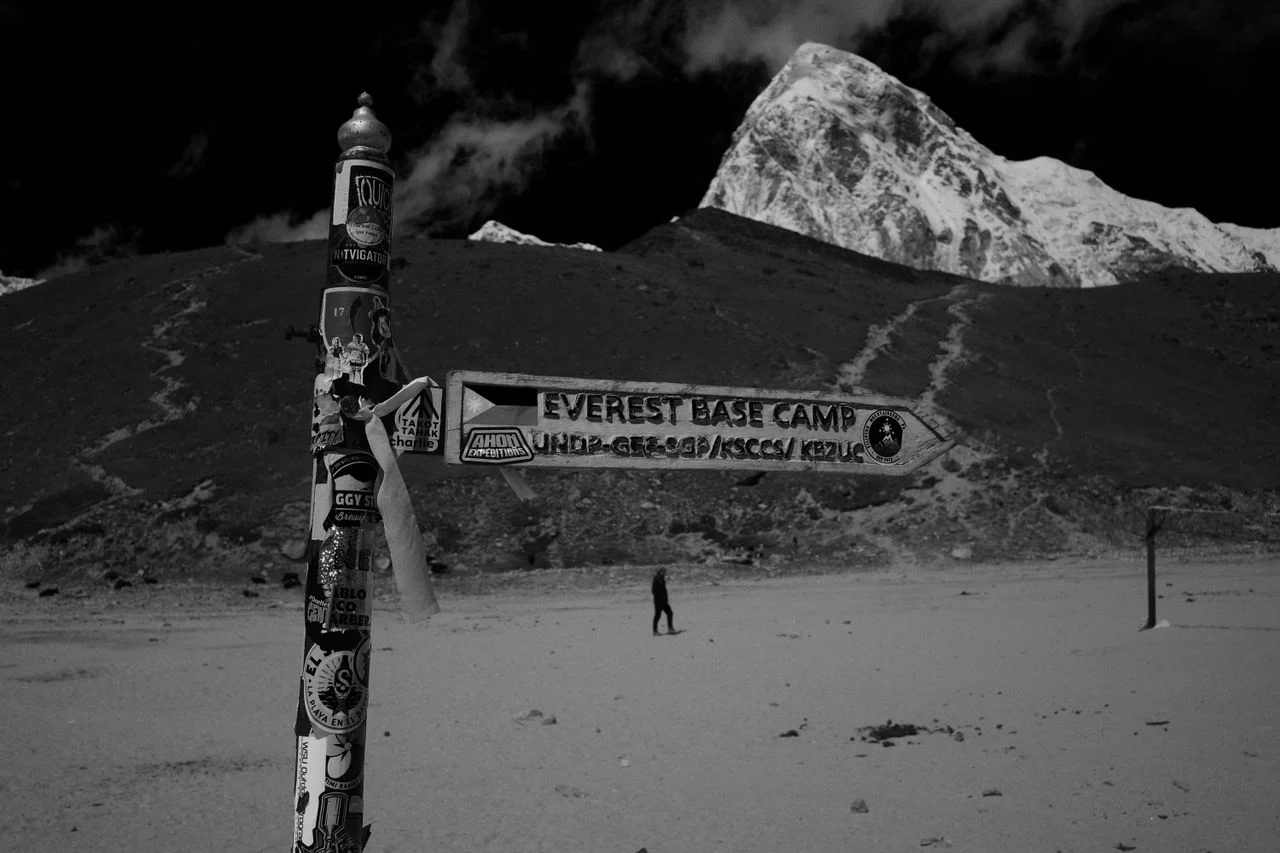
Everest Base Camp is a campsite on the Khumbu Glacier at 5,364 meters. It is the staging area for climbing teams and the final destination for trekkers. From Base Camp, Everest’s summit remains hidden behind the mountain’s massif; only the upper reaches are visible.
The Nepal-side Base Camp sits at approximately 27.9900° N, 86.8526° E, about 2 kilometers west-southwest of the summit’s latitude-longitude position. This small horizontal distance masks the enormous vertical difference.
| Feature | Mount Everest Summit | Everest Base Camp |
|---|---|---|
| Elevation | 8,848.86 meters | 5,364 meters |
| Latitude | 27.9881° N | Approximately 27.9900° N |
| Longitude | 86.9250° E | Approximately 86.8526° E |
| Accessibility | Climbing expedition required | Trekking accessible |
| Time to Reach | 6-8 weeks | 12-14 days round trip |
Finding Mount Everest on a Map: A Practical Guide
Different map types require different approaches. Here is how to locate Everest on the map across various formats.
World Map
-
Find Asia, the largest continent.
-
Locate the Indian subcontinent in the south.
-
Trace north to the Himalayan mountain band.
-
Look for the label “Mt. Everest” or “Sagarmatha.”
-
Note its position on the Nepal-China border.
Asia Map
-
Identify Nepal, a small country between India and China.
-
Focus on Nepal’s northern border.
-
Find the point where Nepal, China, and the Himalayan crest intersect.
-
Everest sits at this intersection, slightly east of Nepal’s center.
Nepal Map
-
Locate Kathmandu, the capital.
-
Move northeast toward the border with Tibet.
-
Identify the Solukhumbu District.
-
Find Sagarmatha National Park in the district’s northern portion.
-
Everest anchors the park’s northern boundary.
Digital Map
-
Open Google Maps or Apple Maps.
-
Type “Mount Everest” or “27.9881, 86.9250.”
-
Use satellite view to see the mountain’s triangular summit.
-
Zoom out to understand the regional context.
-
Switch to terrain view for topographic detail.
Topographic Map
-
Look for tightly clustered contour lines indicating steep elevation gain.
-
Find the highest elevation marker in the area.
-
Search for the label “Sagarmatha” or “Mount Everest.”
-
Identify adjacent features like Lhotse, Nuptse, and the Khumbu Glacier.
The Nepal Side: Everest’s Southern Face
The southern slopes of Mount Everest fall within Nepal’s borders, specifically in the Solukhumbu District of Koshi Province. This entire area is protected within Sagarmatha National Park, a UNESCO World Heritage Site established in 1976.
Nepal’s Everest region is characterized by steep, forested valleys at lower elevations, transitioning to alpine meadows and eventually barren rock and ice near the summit. The Khumbu Valley provides the primary access route for trekkers and climbers.
The Nepal side receives more precipitation than the Tibet side due to monsoon patterns. This creates richer vegetation in the lower zones but also contributes to the Icefall’s danger—a constantly shifting mass of seracs and crevasses that climbers must navigate.
Why the Nepal Side Matters for Travelers
For most people searching where Mount Everest is located, the practical follow-up question is how to visit. The Nepal side offers:
-
The famous Everest Base Camp trek
-
No special permits beyond those required for the national park
-
Established teahouse infrastructure
-
A well-developed trail system
-
Cultural immersion in Sherpa villages
At Merriment Treks, we operate exclusively on the Nepal side, guiding travelers through the Khumbu Valley from Lukla to Everest Base Camp and back.
The Tibet Side: Everest’s Northern Face
The northern slopes of Everest lie within the Tibet Autonomous Region of China. This side is geographically different from the Nepal side in several important ways.
The Tibet side is much drier, receiving far less precipitation than the southern slopes. This results in less vegetation and fewer glaciers, though the Rongbuk Glacier on the north side is substantial. The terrain is more open and plateau-like, with Everest rising abruptly from the high Tibetan landscape.
Access to the Tibet side requires special permits for foreign travelers. The North Base Camp sits at approximately 5,150 meters and can be reached by road, though the road is rough and the altitude makes travel challenging.
Tibet Terminology: Getting It Right
When discussing Everest’s northern side, precise terminology matters. “Tibet” is commonly used but should be understood as the Tibet Autonomous Region of China. It is not an independent country. The Chinese government administers this region, and all travel there falls under Chinese jurisdiction.
This distinction is important because some maps show Tibet as a separate entity, while political maps show it as part of China. Both representations reflect different historical perspectives, but the current political reality is that Tibet is an autonomous region within the People’s Republic of China.
The Himalayan Context: Everest’s Mountain Neighborhood
Mount Everest does not stand alone. It is part of a mountain community that includes some of the highest peaks on Earth.
Lhotse (8,516 meters) sits immediately south of Everest, connected by the South Col. It is the fourth-highest mountain in the world and shares Everest’s Base Camp. Climbers reaching Everest’s summit from the south often traverse Lhotse’s upper slopes.
Nuptse (7,861 meters) forms Everest’s western ridge. Though less famous than Lhotse, Nuptse creates the dramatic wall visible from Base Camp and the Khumbu Valley.
Pumori (7,161 meters) stands northwest of Base Camp. Its pyramid shape is a familiar sight for trekkers, and it is sometimes called “Everest’s Daughter.”
Cho Oyu (8,188 meters) is the sixth-highest mountain on Earth, located approximately 30 kilometers west of Everest.
Makalu (8,485 meters) is the fifth-highest mountain, situated about 20 kilometers east of Everest.
These peaks form the Mahalangur Himal, one of the most concentrated collections of extreme elevation on the planet.
Kathmandu to Everest: Understanding the Geographic Relationship
Kathmandu, Nepal’s capital, is the gateway to the Everest region. The city sits at 1,400 meters in the Kathmandu Valley, approximately 160 kilometers southwest of Mount Everest as the crow flies.
However, there is no direct road from Kathmandu to Everest. The terrain between the capital and the mountain is extremely rugged, crossing multiple river valleys and mountain passes. The practical journey involves:
-
Flight to Lukla – A 30-40 minute flight from Kathmandu to the mountain airstrip at Lukla (2,860 meters).
-
Trek to Phakding – A 3-4 hour walk from Lukla to the first night’s stop.
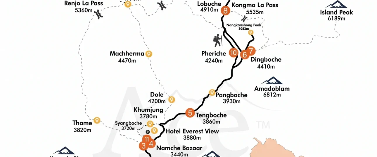
-
Trek to Namche Bazaar – A 5-6 hour climb to the region’s main trading hub (3,440 meters).
-
Multi-day trek – Continuing through Tengboche, Dingboche, and Lobuche before reaching Everest Base Camp.
The straight-line distance between Kathmandu and Everest is approximately 160 kilometers, but the trekking route covers substantially more distance due to elevation changes and trail conditions.
Sagarmatha National Park: The Protected Landscape
Sagarmatha National Park covers 1,148 square kilometers on the Nepal side of the Everest region. The park ranges from 2,845 meters at its lowest point to the summit of Everest at 8,848 meters, encompassing one of the most extreme elevation gradients on Earth.
The park protects:
-
High-altitude glacial systems
-
Alpine and subalpine vegetation
-
Significant wildlife, including snow leopards and Himalayan tahr
-
Sherpa cultural sites and monasteries
-
The upper reaches of the Khumbu Valley
UNESCO World Heritage Status
Sagarmatha National Park was inscribed as a UNESCO World Heritage Site in 1979. The designation recognizes the park’s outstanding natural beauty and its importance for biodiversity conservation. The park’s name comes from the Nepali word for Everest: Sagarmatha, meaning “Forehead of the Sky.”
Common Misconceptions About Mount Everest’s Location
Misconception: Everest is entirely inside Nepal
While Nepal controls the southern approaches and hosts the most popular trekking routes, the summit itself sits on the border with China. The mountain is genuinely shared.
Misconception: Everest is in Tibet, not China
Tibet is not an independent country. It is the Tibet Autonomous Region of China. When someone says Everest is in Tibet, they are identifying the Chinese side of the mountain.
Misconception: Everest is visible from Kathmandu
Everest is not visible from Kathmandu due to intervening mountain ranges. The capital offers no direct view of the mountain, though on very clear days, some viewpoints in the Kathmandu Valley claim distant visibility.
Misconception: You can drive to Everest
On the Nepal side, there is no road to Everest Base Camp. The Tibet side has a road to North Base Camp, but it requires special permits and is not a standard tourist route.
Misconception: Everest Base Camp is at Everest’s foot
Base Camp is more than 3,500 meters below the summit. It is the starting point for climbing, not the mountain itself.
Practical Map Resources for Finding Mount Everest
For readers who want to explore Everest’s location further, several resources provide excellent detail.
Digital Resources
-
Google Maps – Reliable for basic location
-
Google Earth – Excellent for 3D terrain visualization
-
Maps.me – Useful offline maps for trekkers
-
Gaia GPS – Detailed topographic mapping
Physical Maps
-
National Geographic Everest Base Camp Map
-
Nepa Maps Khumbu series
-
Himalayan MapHouse Everest Region
Online Geographic Databases
-
Peakbagger – Mountain database with coordinates
-
SummitPost – Detailed mountain information
-
Nepal Tourism Board official maps
The Geographic Significance of Everest’s Location
Everest’s position at the Nepal-China border is not arbitrary. The mountain sits at the collision zone between the Indian and Eurasian tectonic plates. This collision, ongoing for approximately 50 million years, has created the Himalayan range and continues to push Everest higher at a rate of approximately 4 millimeters per year.
The mountain’s location at this tectonic boundary explains its extreme elevation. The Indian plate is moving north-northeast at approximately 5 centimeters per year, forcing the Eurasian plate upward. Everest is the highest point of this ongoing geological process.
This tectonic context adds depth to understanding where Mount Everest is located. The mountain is not simply a point on a map but the result of immense geological forces that continue to shape the planet.
Seasonal and Practical Considerations
The mountain’s location affects its accessibility throughout the year. The best trekking seasons for the Nepal side are:
Spring (March-May) – Generally clear skies and moderate temperatures. The most popular time for both trekking and climbing.
Autumn (September-November) – Post-monsoon clarity with excellent visibility. The second major trekking season.
Winter (December-February) – Cold temperatures and potential snow at higher elevations. Fewer trekkers but challenging conditions.
Monsoon (June-August) – Heavy rainfall at lower elevations, poor visibility at higher elevations. Not recommended for most trekkers.
These seasonal patterns are directly tied to Everest’s geographic position and its relationship with the Indian monsoon system.
Why Accurate Geography Matters for Trekkers
For those planning an Everest Base Camp trek, understanding Mount Everest’s location is not just academic. It affects:
Acclimatization Planning – Knowing the elevations of Lukla, Namche, Dingboche, and Base Camp helps trekkers prepare for altitude.
Packing Decisions – Understanding the temperature range across the geographic zones informs clothing choices.
Travel Logistics – Knowing the distance and travel time from Kathmandu helps with itinerary planning.
Expectation Setting – Understanding that Everest is not visible from Kathmandu prevents disappointment.
At Merriment Treks, we ensure our travelers understand these geographic realities before they arrive in Nepal.
The Cultural Geography of Everest
The mountain has different names depending on which side you approach from.
Nepal: Sagarmatha, meaning “Forehead of the Sky” in Nepali.
Tibet: Chomolungma, meaning “Goddess Mother of the World” in Tibetan.
International: Mount Everest, named after Sir George Everest, a former Surveyor General of India.
These names reflect the mountain’s dual geography and the different cultural relationships with the peak on each side.
FAQs about Where Is Mount Everest Located on a Map
1. Where is Mount Everest located on a map?
Mount Everest is located on the Nepal-China border in the Himalayas. On a world map, find Asia, locate the Indian subcontinent, trace north to the Himalayan range, and look for the mountain at approximately 28° North latitude and 87° East longitude.
2. What country is Mount Everest in?
Mount Everest is in both Nepal and China. The summit sits on the international border, with the southern slopes in Nepal and the northern slopes in China’s Tibet Autonomous Region.
3. Is Mount Everest in Nepal or China?
Mount Everest is in both Nepal and China. The border runs across the summit, so neither country can claim exclusive ownership.
4. Is Mount Everest in Tibet?
The northern side of Mount Everest is in Tibet, which is the Tibet Autonomous Region of China. Tibet is not an independent country but a region within China.
5. Where exactly is Mount Everest located?
Mount Everest is located at 27.9881° N latitude and 86.9250° E longitude. It sits in the Mahalangur Himal sub-range of the Himalayas, within Sagarmatha National Park on the Nepal side.
6. What are Mount Everest’s coordinates?
Mount Everest’s summit coordinates are 27.9881° N latitude and 86.9250° E longitude. These use the WGS84 datum standard for digital mapping.
7. What mountain range is Mount Everest in?
Mount Everest is in the Himalayas, specifically the Mahalangur Himal sub-range. This section contains four of the world’s fourteen 8,000-meter peaks.
8. Where is Mount Everest located in Nepal?
In Nepal, Mount Everest is in the Solukhumbu District of Koshi Province, within Sagarmatha National Park. The area is in the northeastern part of the country.
9. Where is Everest Base Camp compared with Mount Everest?
Everest Base Camp is on the Khumbu Glacier at 5,364 meters, approximately 3,500 meters below the summit. It is about 2 kilometers west-southwest of the summit’s coordinates.
10. How far is Mount Everest from Kathmandu?
Mount Everest is approximately 160 kilometers northeast of Kathmandu as the crow flies. However, no direct road exists, and the journey requires a flight to Lukla followed by multi-day trekking.
11. How do you find Mount Everest on Google Maps?
Open Google Maps and type “Mount Everest” or “27.9881, 86.9250” into the search bar. The map will center on the summit. Switch to satellite or terrain view for more detail.
12. What is Mount Everest’s elevation?
Mount Everest’s officially recognized elevation is 8,848.86 meters (29,031.7 feet) above sea level. This figure was updated in 2020 based on joint Nepal-China surveys.
13. What is Mount Everest called in Nepal?
In Nepal, Mount Everest is called Sagarmatha, meaning “Forehead of the Sky” in Nepali. The surrounding national park bears this name.
14. What is Mount Everest called in Tibet?
In Tibet, Mount Everest is called Chomolungma, meaning “Goddess Mother of the World” in Tibetan.
15. Which side of Mount Everest is in Nepal?
The southern side of Mount Everest is in Nepal. This includes the Khumbu Valley, Sagarmatha National Park, and the famous Everest Base Camp trekking route.